


Smart highway reconstruction and expansion
 |
System Introduction |
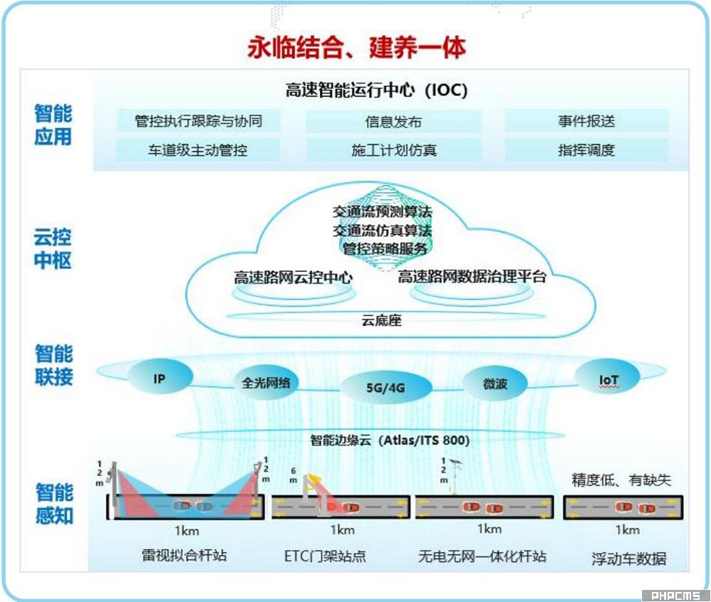
To address issues such as traffic congestion, frequent accidents, and significant traffic flow reduction caused by lane closures during highway reconstruction and expansion, a cloud-based control center solution combining holographic perception, comprehensive understanding, and precise management is implemented. This ensures smooth and safe traffic flow on reconstruction and expansion sections around the clock, while also facilitating rapid response to incidents on operational sections, thereby enhancing carrying capacity. This achieves a combination of permanent and temporary infrastructure, and integrated construction and maintenance.
Significantly improved road service levels: Traffic flow density and speed are fully perceived in powerless and network-free locations such as road transition zones, early warning zones, and construction zones, enabling proactive control and prediction 60 minutes in advance.
Real-time automatic event/accident detection and reporting: Congested vehicles, slow-moving vehicles, and accidents are automatically detected and reported in real time, supporting rapid response to road incidents.
Enhanced road capacity during reconstruction/expansion/major repair/maintenance periods: Through a comprehensive, all-encompassing solution, congestion duration is reduced, and the capacity and load-bearing capacity of reconstruction, major repair, and maintenance sections are improved.
Combined permanent and temporary solutions for long-term customer benefits: The construction of a perception and cloud control center system meets both traffic organization optimization needs during reconstruction and expansion periods and congestion mitigation and smooth traffic flow needs during operation, achieving a combination of permanent and temporary solutions and integrated construction and maintenance.
| |
System Function |
Full road condition awareness

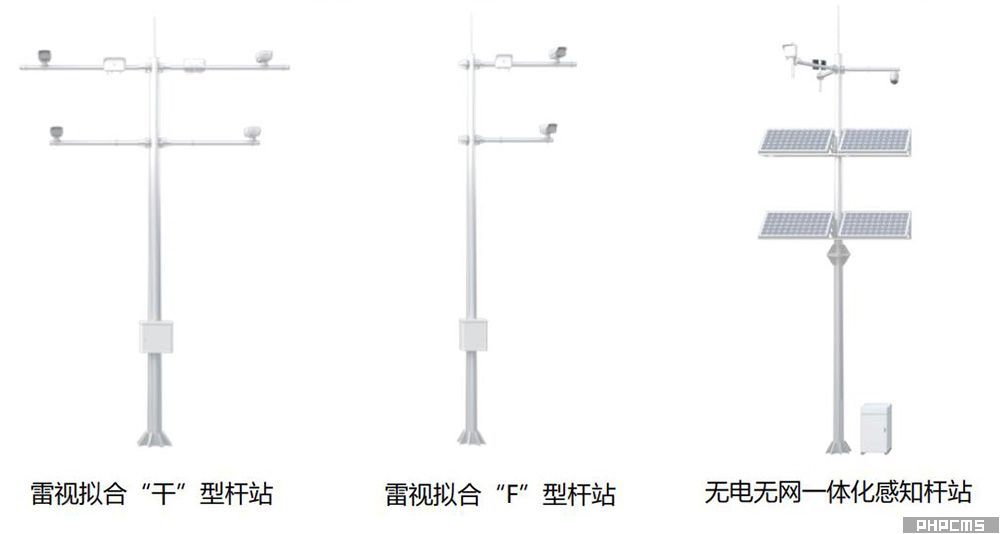
• Long-distance deployment of radar-guided pole stations (km-level) and ultra-wide 4+1 lane coverage, saving on pole construction costs.
• 95% flight path detection accuracy and millisecond-level low latency provide excellent sensing data support for upper-layer applications.
• Near all-weather data sensing, easily handling sensing data collection in snow/fog/rain weather and low-light conditions at night.
• Dedicated solutions for road sections without electricity or network access, utilizing self-generated power and self-networking capabilities to achieve integrated coverage of sensing blind spots.
Comprehensive understanding of the road network
• Unified platform, computing power & data collaboration: Enables real-time data interaction and sharing, adhering to the unified requirements of the provincial platform.
• Upgraded cognitive decision-making: Traffic situation monitoring and prediction; AI algorithm upgrades quickly detect traffic incidents; traffic flow simulation calculations provide precise control strategies.
• Low carbon and energy saving: Green prefabricated data center, rapid deployment, green and energy-saving, PUE meets national demonstration standards.
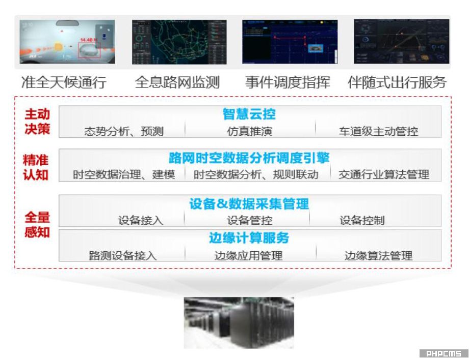
Accurate situation prediction
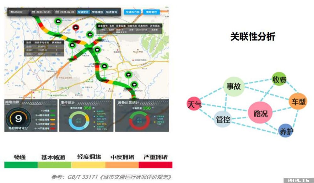
• Road Capacity: Calculates the maximum traffic volume and road capacity under different traffic control conditions and weather conditions based on actual traffic flow data.
• Congestion Index: Calculates the road segment's operating status and congestion index based on the average vehicle speed and free-flow speed of the road segment.
• Situation Prediction: Real-time acquisition of current traffic flow data, weather, event, and construction data, combined with historical data analysis, enables prediction of traffic conditions for each road segment at 5 minutes, 15 minutes, 30 minutes, and 1 hour.
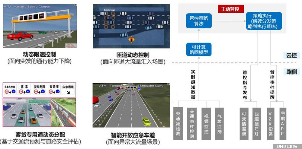
Proactive control in advance
• Proactive Control: Lane-level refined control strategies, enabling collaborative control operations among multiple parties (owners/highway police/road administration).
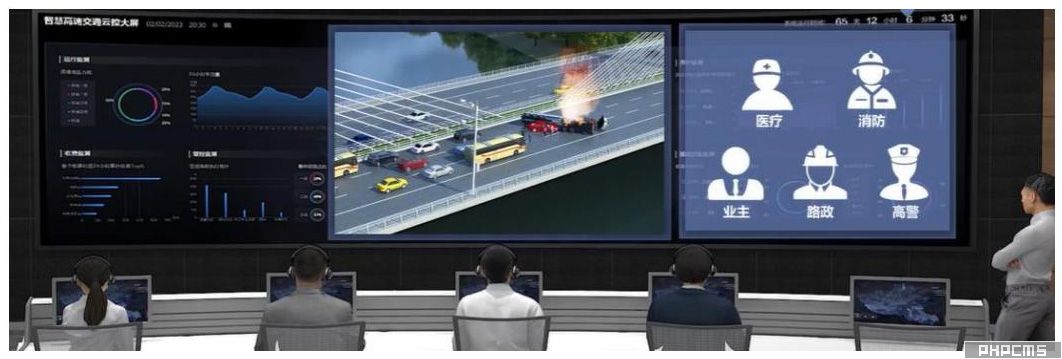
• Unified Communication and Command: Visual linkage, process tracking and recording, significantly improving efficiency.
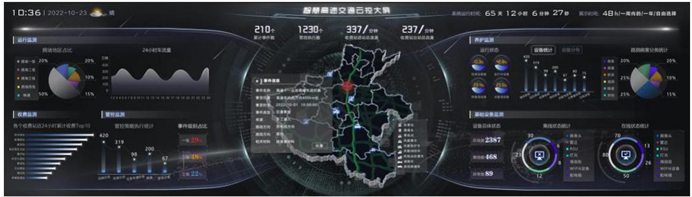
High-speed intelligent monitoring system (loc) provides a comprehensive view of traffic conditions in one map.
• Comprehensive Traffic Overview: A single map displays traffic situation monitoring and flow forecasting, providing insights into future traffic conditions.
• Intuitive Traffic Simulation: Simulates pre-construction plans and control measures, and evaluates the effectiveness of these measures afterward.
• Comprehensive Road Information: All aspects of road operations—construction, management, maintenance, operation, and services—are visualized on a single screen.
Emergency communication, multi-terminal converged visual display, one-screen dispatch and command
• A single screen provides a comprehensive overview of all resources, allowing for real-time monitoring of resource distribution.
• Unified network integration enables cross-terminal hybrid grouping and supports multi-channel reporting.