


Highway Traffic Condition Survey System
 |
System Introduction |
In recent years, various highway traffic condition surveying equipment has been rapidly promoted and popularized in the field of highway traffic condition surveying, and the methods of highway traffic condition surveying are gradually developing towards automation, networking, and real-time processing. However, due to the lack of unified technical requirements for the selection and use of survey equipment by highway traffic condition surveying agencies at all levels, the quality of survey data varies, affecting the healthy and orderly development of highway traffic condition surveying work. In order to guide highway traffic condition surveying agencies at all levels in selecting and using qualified highway traffic condition surveying equipment, ensure the accuracy and timeliness of highway traffic condition survey data collection, and meet the needs of highway traffic condition surveying work, it is recommended that the use of LiDAR intelligent traffic flow detection devices be one of the main products of highway traffic condition surveying equipment.
Laser + Video Traffic Survey System
The system comprises a front-end subsystem, a transmission subsystem, and a back-end management subsystem. The front-end subsystem includes a capture unit, a laser detection unit, a laser modeling unit, and a laser data server, primarily implementing traffic data survey functions. The back-end management subsystem mainly refers to the traffic survey platform, such as third-party platforms at the city/county level, provincial platforms, or the Ministry of Transport's traffic survey platform, primarily realizing the functions of data aggregation, analysis, display, and storage. The transmission subsystem uploads survey data from the front-end subsystem to the back-end management subsystem, enabling real-time transmission of traffic survey data and real-time viewing and browsing of traffic survey video footage.
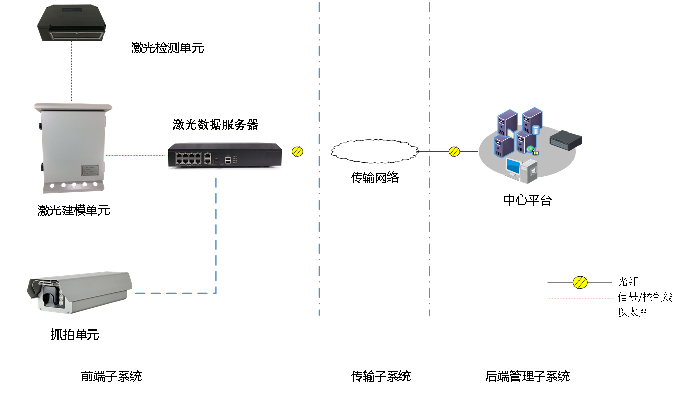
The video capture unit and the laser detection unit work together to identify and detect vehicles. The laser data server aggregates, statistically analyzes, and processes the survey data to obtain data in a format that conforms to the survey standards. This data is then uploaded to the traffic survey platform via a transmission network. In addition to survey data, surveillance video data and equipment status information are also uploaded to the platform simultaneously. The monitoring center can play back or download recordings as needed and monitor equipment information in real time to ensure the stability and reliability of the system.
Dual-laser traffic situation survey system
Dual-laser traffic situation survey system
The system consists of a laser detection unit and a laser application unit. Utilizing pure laser technology, the front-end equipment is simple to install, requires no road surface damage, and is unaffected by road construction, making it a non-contact traffic monitoring device.
The dual-laser traffic situation survey system is based on advanced laser detection technology, classifying vehicles by scanning their three-dimensional shape. It features high classification accuracy and strong anti-interference capabilities.
The laser application unit of the dual-laser vehicle detection system uses an embedded chassis, which is small in size, lightweight, and has simple external wiring. It employs an advanced industrial-grade processor as the core controller, with internal boards communicating via a high-speed data bus to share various information. Advanced multi-information fusion technology ensures superior system performance and stable, reliable operation. The laser sensor uses the most advanced high-speed scanning ranging sensor currently available, ensuring stability, reliability, and high scanning accuracy.

