


Highway Demonstration Zone
 |
System Introduction |
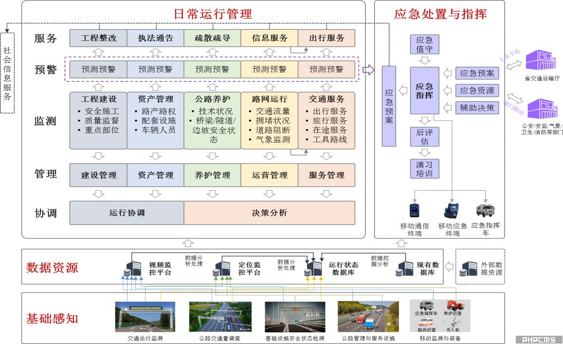
Guided by the smart highway policies issued by the Ministry of Transport, and based on the highway management system and business needs, this system aims to achieve "smart monitoring, smart management, smart decision-making, and smart services." Following the principles of "goal-oriented, modular advancement, demonstration-led, and market-driven," it leverages multi-dimensional sensing capabilities in highway transportation infrastructure, Internet+ intelligent transportation, and IoT intelligent automation technologies. Focusing on facilitating public travel, improving transportation efficiency, enhancing traffic safety, and strengthening environmental protection, it integrates traditional monitoring equipment and intelligent IoT terminals, combining various digital data collection methods such as Internet+ big data. It comprehensively integrates diverse and heterogeneous data resources to achieve new value data mining; integrates business applications to achieve refined traffic control; and constructs the "brain" of the smart highway system to achieve comprehensive decision-making supervision and provide diversified and personalized services.
The smart highway system encompasses modules such as information collection, big data processing and analysis, intelligence information exchange, video network management, road network detection coordination management, public information services, statistical queries, data backup and system recovery, equipment management, system security, and reserved shared interfaces.
| |
Business Architecture |
| |
System Architecture |
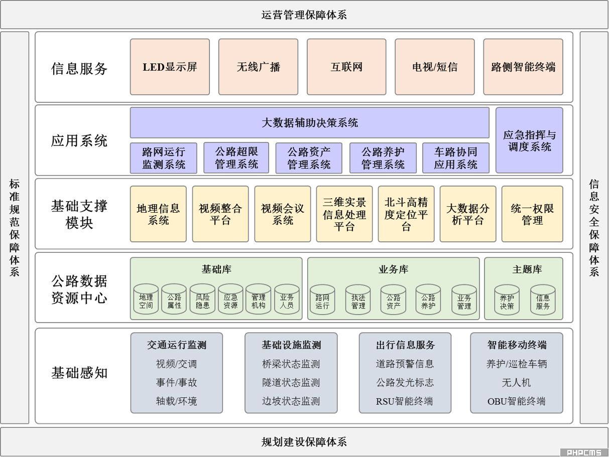
| |
System Architecture |
Highway Network Video/Event Monitoring System

By scientifically deploying intelligent sensing cameras, combining point, line, and area methods, real-time collection of vehicle characteristic data, traffic flow data, traffic incident information, and road segment operation status information is achieved. This constructs an intelligent road network monitoring network, creating powerful full-network perception capabilities, agile business response capabilities, in-depth data mining capabilities, and precise analysis and judgment capabilities.
Based on the business requirements of highway network monitoring, the system expands to include richer and more intelligent intelligent sensing capabilities for highway network monitoring, solving practical problems such as the difficulty in managing and maintaining video image resources and effectively deleting redundant information due to the current excessive amount of monitoring footage and information. Through intelligent sensing equipment, full video coverage is achieved for core highway business scenarios (accident-prone sections, sections in severe weather, tunnels, bridges, service areas, ramp interchanges, overload control stations, and traffic control stations), realizing full-network intelligent perception, dynamic monitoring, travel services, and emergency command.
The video/event monitoring system is mainly used for monitoring and recording vehicles at intersections, key congested sections, and dangerous sections, including vehicle images, license plates, and vehicle characteristic data. Meeting user needs mainly involves capturing images of motor vehicles passing through the aforementioned road sections, recognizing vehicle license plates, collecting vehicle feature data, and setting up monitoring, comparison, and alarm functions.
Highway Traffic Condition Survey System
In recent years, various highway traffic condition surveying equipment has been rapidly promoted and popularized in the field of highway traffic condition surveying, and the methods of highway traffic condition surveying are gradually developing towards automation, networking, and real-time processing. However, due to the lack of unified technical requirements for the selection and use of survey equipment by highway traffic condition surveying agencies at all levels, the quality of survey data varies, affecting the healthy and orderly development of highway traffic condition surveying work. In order to guide highway traffic condition surveying agencies at all levels in selecting and using qualified highway traffic condition surveying equipment, ensure the accuracy and timeliness of highway traffic condition survey data collection, and meet the needs of highway traffic condition surveying work, it is recommended that the use of LiDAR intelligent traffic flow detection devices be one of the main products of highway traffic condition surveying equipment.
Integrated Transportation Meteorological Early Warning and Monitoring System
The integrated traffic meteorological early warning and monitoring system is built upon GIS geographic information and meteorological big data. Based on data collected from highway meteorological stations, road surface conditions, and equipment status, and relying on big data from meteorological departments, it combines road segment heat map data analysis to provide highway managers with minute-level and kilometer-level near-term weather forecasts, comprehensive disaster information early warnings, trend forecasts, and quantifiable, precise data to provide decision-making support for traffic control. This enables comprehensive monitoring and dynamic management of highway meteorology, allowing for the advance deployment of response strategies, reducing highway accident rates, and improving highway utilization efficiency and economic benefits.
Automated Highway Icing Handling System
The automated highway icing control system, combined with the traffic weather early warning and forecasting system, utilizes big data analysis and processing on a cloud platform and IoT technologies to automatically handle highway icing issues. This system can be applied to various road sections, including highways, urban overpasses, road bridges, long and steep slopes, airport access gates, tunnel entrances and exits, and mountain roads; it is particularly effective on uphill and downhill sections prone to icing, ensuring safe road travel during winter.
Fog Zone Driving Safety Guidance System
This system is a fully intelligent, proactive road traffic safety and accident prevention system designed for application scenarios such as road sections prone to heavy fog, sharp bends and steep slopes with relatively low road alignment indicators, sections with relatively high nighttime accident rates, and sections with relatively high rates of accidents caused by driver fatigue. It is widely known as a "fog-day wonder" among users.
Slope Dynamic Monitoring System
Highway slopes, especially in mountainous areas, present complex engineering conditions, numerous influencing factors, and significant maintenance challenges. Slope deformation and damage can cause substantial disruption to highway operation and management. Traditional slope monitoring relies primarily on on-site inspections by maintenance personnel, using manual visual assessment to monitor and judge slope safety, which cannot provide a timely and comprehensive understanding of potential safety risks.
The Slope Dynamic Monitoring System is a comprehensive monitoring system integrating structural analysis and calculation, computer technology, communication technology, network technology, and sensor technology. It can perform functions such as surface displacement monitoring, deep displacement monitoring, crack displacement monitoring, rainfall monitoring, and soil moisture monitoring. This system is a professional online real-time monitoring system for comprehensive safety slopes, realizing the digitization and networking of slope monitoring.
Bridge Dynamic Monitoring System
Modern large bridges are crucial nodes on major transportation arteries. The safety of bridge structures has a significant impact on transportation. However, due to the lack of a comprehensive safety monitoring system for large bridge structures, anomalies in structural conditions cannot be detected in a timely manner. Once a traffic accident occurs, it can cause huge economic losses and severe social impacts. Therefore, establishing a bridge dynamic monitoring system based on precise meteorological data to provide management units with long-term, real-time monitoring data is a fundamental measure to avoid traffic accidents.
Automated Tunnel Inspection System
This system combines advanced robotics and non-destructive sensing IoT technology to continuously and spatially acquire operational status information of equipment within the tunnel over a long period. It analyzes various status characteristics, including tunnel structural status, equipment operating status, vehicle traffic status, road surface status, and tunnel weather conditions. This allows for understanding changes caused by damage or degradation during tunnel operation, and diagnostic methods are used to determine the occurrence, location, and extent of damage. The system assesses the overall health of the tunnel's operation and detects anomalies before critical points threaten its structural safety. It triggers early warning signals for tunnels under special weather or traffic conditions, or when tunnel operation is severely abnormal, providing a basis and guidance for tunnel maintenance, upkeep, and management decisions.
Highway Defect Inspection System
This video-based AI-powered highway defect inspection system combines automated information acquisition with artificial intelligence. It enables accurate on-site data collection, AI-based filtering, transmission, and analysis throughout the entire process, and can interface with business management systems.
Variable Relay Information System
The variable relay information system primarily disseminates traffic control information and provides traffic safety information. Information dissemination and guidance, based on an information integration platform, implements three business functions on the information dissemination terminal: 1) dissemination of road condition information; 2) dissemination of traffic control information; and 3) traffic safety reminders.
Highway Non-Site Enforcement Non-Stop Overload Detection System
The highway bridge non-site enforcement non-stop overload detection system organically integrates non-stop dynamic weighing, video surveillance, image capture and license plate recognition, and an information dissemination system to establish a 24/7 monitoring system for overloaded freight vehicles. It effectively detects and monitors overloaded freight vehicles, providing traffic management departments with a basis for enforcement.
Road Safety Early Warning
Some national and provincial highways have complex terrain, narrow roads, numerous curves, and steep slopes. Some also pass through villages, resulting in complex traffic conditions and frequent collisions between vehicles on main roads and those on side roads. Although various warning signs and slogans, such as conventional wide-angle mirrors and signs, have been installed in accident-prone sections, the effect is still not ideal. To address traffic safety issues on challenging terrains or complex road sections such as sharp turns and steep bends, there is an urgent need for intelligent transportation technologies to provide real-time dynamic detection, alerts, and guidance for road traffic, achieving the goal of safe and orderly road traffic and protecting the lives and property of drivers.
Road safety early warning is an intelligent system applicable to various traffic scenarios, primarily comprising a vehicle monitoring system, early warning equipment, and a control platform. The vehicle monitoring system uses advanced microwave vehicle detectors to monitor passing vehicles, measuring their speed, vehicle type, etc., and sends the data to a roadside intelligent interactive base station. The base station analyzes and distributes the data, and controls voice and display devices to alert vehicles, improving driving safety. The base station can also transmit road traffic data to the control platform via fiber optic or 4G, providing a clear and centralized view of traffic conditions.
The curve meeting warning system is installed on the right side of both ends of the curve, in the direction of vehicle travel. After the microwave vehicle detector detects an approaching vehicle, it sends the vehicle information to the base station on the other side of the curve. The display screen shows the meeting information, and an audio message plays, reminding drivers to slow down.
Smart Road Bumpers
Smart road bumper systems provide real-time, accurate, and intuitive displays of road traffic conditions.
They act as the intelligent eyes guiding traffic beyond visual range, effectively alleviating traffic congestion and improving the coverage and timely warning rate of automatic detection of operational safety incidents.
In low-visibility environments, artificial intelligence provides a highly visible dynamic trail to vehicles behind, synchronized with their movement to meet the minimum safe vehicle separation requirements in adverse conditions. This effectively reduces the probability of road accidents caused by fog and can reduce or avoid road closures due to fog.
Smart Traffic Cones
Portable intelligent road safety facilities, industrial-grade dustproof, waterproof, and shockproof, can be directly installed on safety installations. They support warning sign settings, voice interaction, quick installation, and are equipped with an onboard charging box supporting solar charging. They can operate continuously 24/7, featuring one-button start, precise alerts, accurate positioning, internet dissemination, and early warning functions. They support both dual-node and single-node configurations.
Smart Rest StopsThe Smart Rest Stop system comprises multiple subsystems providing convenient services to a wide range of highway traffic participants and tourists. The establishment of this system significantly enhances the service capabilities and information technology level of ordinary highway rest stops.
AR Real-Scene Perception
Addressing the shortcomings of traditional methods in obtaining road traffic information, lacking comprehensive control over traffic areas, and presenting resources in a less intuitive way, AR real-scene fusion technology is used to achieve a full-dimensional display of the traffic world, truly making what you can feel visible.
The AR Real-Scene Perception system fully utilizes technologies such as augmented reality, 3D positioning, and artificial intelligence (pattern recognition, event detection, vehicle tracking, etc.). It acquires panoramic video of monitoring points through AR high-point panoramic cameras and links it with low-point cameras within the field of view. This achieves large-scale three-dimensional monitoring and video linkage, focusing on both the overall picture and specific details. It can display low-point camera video in a picture-in-picture format, making it queryable, searchable, locatable, descriptive, alarm-enabled, and linkage-enabled, greatly improving the application mode of the monitoring system and increasing practical efficiency.
Smart Transparent Highways
The Smart Transparent Highway system utilizes traffic gene sequencing to extract precise motion coordinates for each vehicle. Through real-time perception and global integrated analysis, it organically integrates continuous traffic video surveillance footage. This enables efficient traffic incident alerts and continuous evidence collection of traffic violations across different video feeds, breaking through the visual boundaries of traditional traffic management visualization systems. Seamless coverage of scenarios and autonomous vehicles allows for real-time perception of vehicle positions and movement status within the footage. Based on this, it analyzes and calculates various real-time traffic behaviors and events, analyzing traffic trends. This provides real-time traffic data for autonomous vehicles and an information system for traffic managers with global coverage, multi-dimensional perception, and real-time alerts.
